|
The authors argue a carbon roadmap, driven by a simple rule of thumb or carbon law of halving emissions every decade, could catalyse disruptive innovation. A carbon law approach, say the international team of scientists, ensures that the greatest efforts to reduce emissions happens sooner not later and reduces the risk of blowing the remaining global carbon budget to stay below 2 C. The paper notes that a carbon law offers a flexible way to think about reducing carbon emissions. The Carbon law is a powerful strategy and roadmap for ramping down emissions to zero so as to stay within the global carbon budget for stabilizing climate to less than 2 C above preindustrial levels. Joeri Rogelj, also at IIASA, said, The carbon law outlines a global path towards achieving climate and sustainability goals in broad yet quantitative terms. It sketches a general vision of rapid emission reductions in conjunction with the development of sustainable carbon dioxide removal options. https://www.sciencedaily.com/releases/2017/03/170323141338.htm 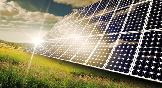
0 Comments
When the Deepwater Horizon drilling pipe blew out seven years ago, beginning the worst oil spill in U.S. history, those in charge of the recovery discovered a new wrinkle: the millions of gallons of oil bubbling from the sea floor werent all collecting on the surface where it could be skimmed or burned. The material not only easily absorbs oil from water, but is also reusable and can pull dispersed oil from the entire water column - not just the surface. This foam has lots of nooks and crannies, like an English muffin, which could provide ample surface area to grab oil; but they needed to give the foam a new surface chemistry in order to firmly attach the oil-loving molecules. At tests at a giant seawater tank in New Jersey called Ohmsett, the National Oil Spill Response Research & Renewable Energy Test Facility, the Oleo Sponge successfully collected diesel and crude oil from both below and on the water surface. Oleo Sponge could potentially also be used routinely to clean harbors and ports, where diesel and oil tend to accumulate from ship traffic, said John Harvey, a business development executive with Argonnes Technology Development and Commercialization division. https://www.sciencedaily.com/releases/2017/03/170308092505.htm 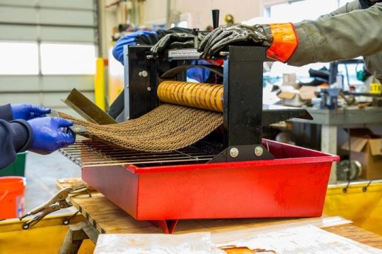 While this number is higher than the previous estimate made in the late 1990s based on ground measurements, the new research includes data on more volcanoes, including some that scientists have never visited, and it is still lower than human emissions of sulfur dioxide pollution levels. He led the effort to catalogue sulfur dioxide emissions sources from human activities and volcanoes and to trace emissions derived from the satellite observations back to their source by using wind data. With daily observations, tracking sulfur dioxide emissions via satellite can also help with eruption forecasting. Along with measuring seismic activity and ground deformation, scientists monitoring satellite data can potentially pick up noticeable increases in gas emissions that may precede eruptions. The satellite data could allow us to target new ground-based measurements at unmonitored volcanoes more effectively, leading to better estimates of volcanic carbon dioxide emissions. The work highlights the necessity of consistent long-term data, according to co-author Nick Krotkov, an atmospheric scientist at NASAs Goddard Space Flight Center in Greenbelt, Maryland, which produces the sulfur dioxide data from the Aura satellite. https://www.sciencedaily.com/releases/2017/03/170309150624.htm 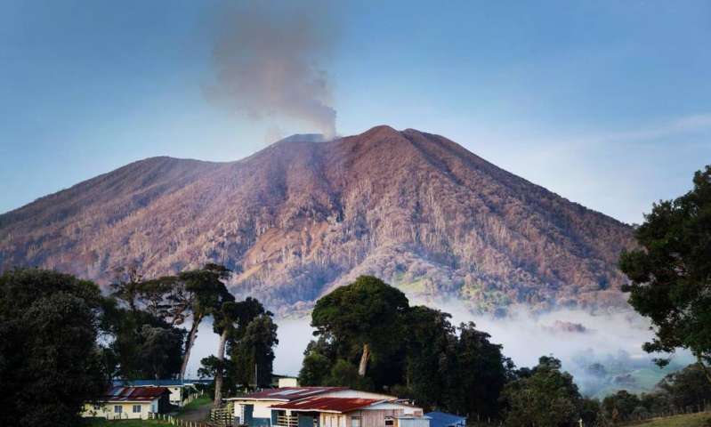 Changing environments and ecosystems were driving the evolution of horses over the past 20 million years. In fact, Cantalapiedra and colleagues were able to show that all these newly evolved species of horses were ecologically very similar. Environmental changes would have produced a lot more fragmented, mosaic-type ecosystems, where populations of horses with similar demands and adaptations could have evolved isolated from one another, resulting in different species but with a similar appearance , points Manuel Hernandez Fernandez at the Complutense Univerity in Madrid. https://www.sciencedaily.com/releases/2017/02/170209142648.htm 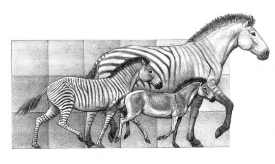 Dry Tortugas National Park is a cluster of small, isolated islands at an important marine crossroads: the Florida Straits, where the Gulf of Mexico and the Caribbean Sea flow into the Atlantic Ocean. Combining these two corals records with three other Dry Tortugas coral cores that stretch back to 1733, the team was able to track 278 years worth of sea surface temperatures. The Dry Tortugas corals show that after a cold spell during the 1960s, sea surface temperatures in the region have warmed by about 1 degrees Fahrenheit between 1970 and 2012. This suggests that there is a close connection between sea temperatures in the area around the Dry Tortugas and the larger AMO. By looking at sea surface temperatures in the Dry Tortugas, climatologists may be able to predict imminent changes that will affect the entire North Atlantic basin, Flannery said. https://www.sciencedaily.com/releases/2017/01/170125091717.htm  Regional sea-level scenarios: Helping US Northeast plan for faster-than-global rise 1/19/171/19/2017 The report, Global and Regional Sea Level Rise Scenarios for the United States, provides regional sea-level rise scenarios and tools for coastal preparedness planning and risk management. The report provides a range of possible scenarios, from at least 1 foot of global sea-level rise by 2100 to a worst-case rise that is 1.6 feet higher than a scenario in a key 2012 study that the report updates. The report also provides four additional global average sea-level rise scenarios through 2100: intermediate-low, intermediate, intermediate-high, and high. From Virginia through Maine and along the western Gulf of Mexico, sea-level rise is projected to be greater than the global average in nearly all global average sea level rise scenarios. For example, the sea in these regions would rise 1 to 1.6 feet higher than the global average rise of 3.3 feet under the intermediate scenario by 2100. https://www.sciencedaily.com/releases/2017/01/170119111004.htm  The subduction zone off the east coast of the archipelago racks up more intermediate-depth and deep earthquakes than any other subduction zone, where one plate of Earths lithosphere dives under another, on the planet. Analyzing data from several seismic surveys with both ocean bottom seismometers and island-based seismic stations, they were surprised to find a zone of intense earthquake activity in the downgoing slab, which they call a seismic belt. It looks like the seismic belt is produced by the sudden flushing of water when the slab warms up enough that the hydrated minerals can decompose and give off their water, said Doug Wiens, the Robert S. Brookings Distinguished Professor of earth and planetary sciences in Arts & Sciences at Washington University. Where the double seismic zone started to break down in Tonga, however, we saw this really active area of earthquakes that we named the seismic belt, Wiens said. The faster the slab was moving, the deeper the earthquakes, and the slower the slab, the shallower the earthquakes. https://www.sciencedaily.com/releases/2017/01/170111151428.htm  For decades scientists have speculated that rising global temperatures might alter the ability of soils to store carbon, potentially releasing huge amounts of carbon into the atmosphere and triggering runaway climate change. A new Yale-led study in the journal Nature finds that warming will drive the loss of at least 55 trillion kilograms of carbon from the soil by mid-century, or about 17% more than the projected emissions due to human-related activities during that period. The study predicts that for one degree of warming, about 30 petagrams of soil carbon will be released into the atmosphere, or about twice as much as is emitted annually due to human-related activities . For Bradford, the analysis provides important clarity on the question of why soil-warming studies appear to provide contradictory evidence, with some showing losses of soil carbon and some showing no change. The study considered only soil carbon losses in response to warming. There are several other biological processes - such as accelerated plant growth as a result of carbon dioxide increases - that could dampen or enhance the effect of this soil carbon feedback.  Since then giant earthquakes have been thought to be possible on any large fault. In the new paper UO researchers show that the maximum size of earthquakes may be controlled by another parameter: the fault curvature. The way people in the science community think about earthquakes is that some fault areas resist failure more than others, and when they break they generate large earthquakes, said lead author Quentin Bletery, a postdoctoral researcher at the UO. What I found is the opposite of what I expected: Very large earthquakes occur on fault areas where the slope is the most regular, or flat. The rupture threshold is more homogeneous along flat faults, allowing larger fault areas to rupture simultaneously, the researchers said. Based on the average curvature inside the giant earthquake rupture areas, the researchers concluded that the likelihood that mega-earthquakes are linked to fault curvatures is more than 99 percent. 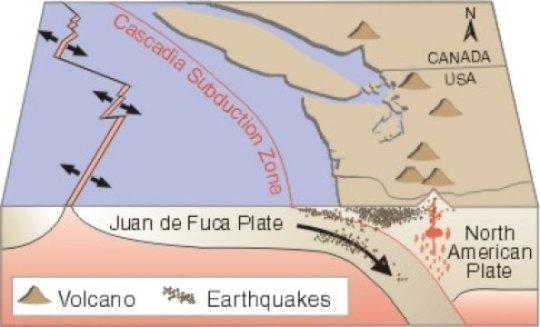 The erosion rates of cliffs along the Sussex coast have rapidly sped up in the last 200 years, a new study has found. The research shows that the erosion rates along Beachy Head and Seaford Head in Sussex had remained relatively stable, at around two to six centimetres each year, for thousands of years. Cliff erosion is irreversible; once the cliffs retreat, they are gone for good. This isotope is created when cosmic radiation reacts with oxygen atoms in the exposed flint rock, so by measuring its accumulation, it acts as a kind of rock clock to show the rate of rock erosion. Since the rate of accumulation has previously been relatively constant, measuring rock samples from across the shore platforms allowed researchers to build a record of how coastal erosion has proceeded over the last 7000 years or so. 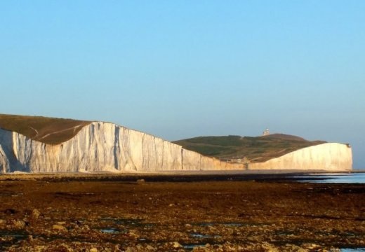 |
AuthorWrite something about yourself. No need to be fancy, just an overview. Archives
February 2017
Categories |
 RSS Feed
